 Trails in the Peter Lougheed Park Area
 Trails in the Peter Lougheed Park Area
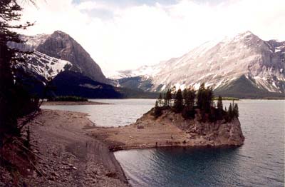
Upper Kananaskis Lake
June 2002: Mount Sarrail (3174 m) on the left and Mount Lyautey (3082 m) on the right frame the Mangin Glacier on the far side of the lake.
Topo Map: Kananaskis Lakes 82 J/11
Trail: Upper Kananskis Lake Circuit, East Shore
Ref: KCTG p. 213
![]()
![]()
![]()
![]()
![]()
All Content © David Wasserman. All rights reserved - Commercial use without express written permission of the copyright holder is expressly forbidden.