 Trails in the Peter Lougheed Park Area
 Trails in the Peter Lougheed Park Area
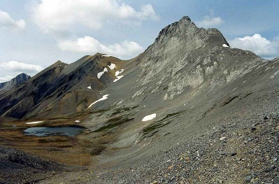
Mount Northover, West Side
August 2005: The scramble route to the summit of Mount Northover, 3003 m, follows the south ridge on the right skyline; the Northover Ridge route passes along the lower slopes on the west side of the peak to reach the ridge at the col in the center skyline. One of the two Northover Lakes is visible on the left. At this point the route has crossed the Continental Divide and you are in British Columbia.
Topo Map: Kananaskis Lakes 82 J/11
Trail: Northover Ridge
Ref: KCTG p. 240
![]()
![]()
![]()
![]()
![]()
All Content © David Wasserman. All rights reserved - Commercial use without express written permission of the copyright holder is expressly forbidden.