 Trails in the Icefields Parkway Area
Howse River Valley
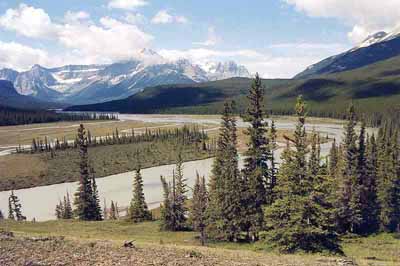
July 2004: The Howse River's broad and braided flats and Mount Outram, 3240 m, greet the hiker on the Glacier Lake trail. The trail goes over the wooded ridge on the right before descending to the lake.
Topo Map: Mistaya Lake 82 N/15
Trail: Glacier Lake
Ref: CRTG p. 136


All Content © David Wasserman. All rights reserved - Commercial use without express written permission of the copyright holder is expressly forbidden.