 The Wilcox Pass Trail
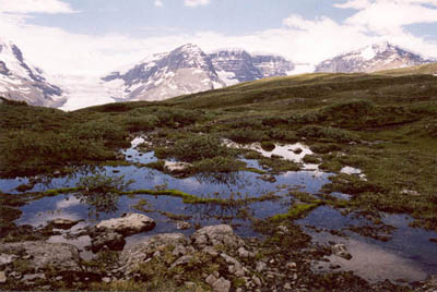
Pond, Meadow, Ice, Rock, Sky
June 1998: The Athabasca Glacier has receded drastically in the last century. Wilcox Pass was originally used as a bypass around the toe of the glacier; now there is room for a highway in the valley bottom. Parts of Mount Andromeda, 3442 m, Snowd
ome, 3460 m, and Mount Kitchener, 3511 m, are visible left to right.
Topo Map: Columbia Icefield 83 C/3, Sunwapta Peak 83 C/6
Trail: Wilcox Pass
Ref: CRTG p. 210


All Content © David Wasserman. All rights reserved - Commercial use without express written permission of the copyright holder is expressly forbidden.