 Trails in the Peter Lougheed Park Area
 Trails in the Peter Lougheed Park Area
Upper Spray River Valley
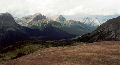
September 2002: Northwest of Burstall Pass, the Spray River passes Mount Leval (2760 m, left edge), Mount Vavasour (2820 m), and Mount Warre (2755 m, centre). Further in the distance are Mount Currie (2810 m) and Mount Morrison (2760 m).
Topo Map: Spray Lakes Reservoir 82 J/14
Trail: Burstall Pass
Ref: KCTG p. 181, CRTG p. 398
![]()
![]()
![]()
![]()
![]()
All Content © David Wasserman. All rights reserved - Commercial use without express written permission of the copyright holder is expressly forbidden.