 Trails in the Peter Lougheed Park Area
 Trails in the Peter Lougheed Park Area
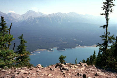
Lower Kananaskis Lake
August 2000: The Elk Range rises across Lower Kananaskis Lake. Highway 40 runs through the gap on the left and behind the Elk Range, over Highwood Pass, 2206 m, the highest point reached by a paved road in Alberta.
Topo Map: Kananaskis Lakes 82 J/11
Trail: Mount Indefatigable Lookout
Ref: KCTG p. 231
![]()
![]()
![]()
![]()
![]()
All Content © David Wasserman. All rights reserved - Commercial use without express written permission of the copyright holder is expressly forbidden.